


A few notes before we begin.
The subject of today’s piece is California Forever. I met the firm’s CEO, Jan Sramek, at Progress Conference 2025, where the seeds of today’s piece were planted. I’m pleased to report that I will be attending Progress Conference 2026 in October, where I will be speaking on driving automation, alongside fellow speakers Dmitri Dolgov, the co-CEO of Waymo, and Ryan Oksenhorn, co-founder of Zipline. (Other speakers include two Nobel laureates and various other luminaries who don’t work on transport, but we won’t hold that against them.) There is no place like Progress Conference to learn about the future we deserve, and meet the builders who are making it happen. Attendance is by invitation; apply for one here.
My investigation When Was Peak Book?, formerly paywalled, is now available to all subscribers. I hope you enjoy it!
In the spring of 1947, William Levitt broke ground on 1,200 acres of Long Island potato farmland, with the aim of building cheap houses, fast, for returning veterans who needed somewhere to live. The resulting community, Levittown, had 17,000 homes on wide residential streets; it immediately became the template for how Americans built greenfield housing, and remains so today.
Levitt was not making a statement about the ideal type of urban form. His aim was only to build what people wanted as quickly and cheaply as he could. Since automobiles were omnipresent and land was cheap, he settled on curvilinear streets on generous lots, with no provision for walkable density.
That was three generations ago, but the legacy lives on. Nassau County, where Levittown was built, today remains almost entirely car-dependent, since its physical form does not permit sufficient transit for car-free living. On the scale of a human lifetime, the choices Levitt made were irreversible. So are the choices made by the innumerable developers who followed Levitt’s pattern.
On 15,000 acres of Solano County, California, roughly midway between Sacramento and San Francisco, Jan Sramek and his team are making their own irreversible choices today.
The company is called California Forever. Its CEO is Jan Sramek, a former Goldman Sachs trader and education entrepreneur who spent the better part of a decade assembling the land and the political coalition necessary for the project. Originally proposed as a new community, through the entitlement process, the city has now become an expansion of an existing city, Suisun (pronounced SOO-soon). A truly new American city, rather than a suburban master-planned community; a city built from bare ground on its own logic; that hasn’t happened at this scale in living memory, which makes it interesting indeed.
The project is complex and contested. It has its advocates (I am one) and its detractors (there are many), who clash over the impact of the project and the value it can add to California and the USA.
None of that is what this piece is about. This piece is about mobility.
Readers may know that I am one of the very few people who has been employed on a project to build a new neighbourhood, with the explicit responsibility of thinking through the mobility elements that would make it up, and how they should interact with housing and urban form. I have written about the conclusions I reached, and the experience of reaching them, before. So I am one of the very few who has parallel experience to what Sramek and company are doing now. Even so, my experience is a loose fit with what is happening in Suisun, because the Quayside project that I worked on featured roads, sewers, and much of its other infrastructure before we began to plan. In many cases we had to colour within the lines, but California Forever is much less constrained. Given that freedom, how bold will the vision be?
To answer that question, earlier this year, I sat down with Sramek to discuss, with the aim of understanding what sort of mobility system the California Forever team wants the Suisun Expansion to have, and whether its approach can bear scrutiny.
Locking In the Right Form
New post-war American development locked in car dependency from the start, by designing for the car as the primary mobility mode. Putting the car at the top of the hierarchy means that many other choices are made immediately. These included wide arterials that tried to accommodate both throughput and access, and largely failed at both; surface parking lots that separated buildings from the street; and setbacks that made walking unpleasant.
These decisions cast the city in amber, or rather, in concrete. Changing any of these after the fact, assuming one could find the political support to do so, would require the physical reconstruction of billions of dollars of infrastructure. This has meant, in effect, that doing anything differently is impossible.
The decisions made at a city’s inception are more-or-less permanent. This means that the decisions California Forever makes about Suisun Expansion now, before construction, will be irreversible. And the first of these irreversible decisions is: the Expansion’s streets will be public realm first, and transport infrastructure second. “Fundamentally, we treat streets first as places for people to spend time in,” Sramek told me, “and second as places where mobility happens.”
The Specific Plan that governs the Expansion’s development encodes this into the physical fabric, with narrow rights-of-way (residential slow streets run as narrow as 20 feet), fine-grain block structure with parcel frontages of 16 to 25 feet, frequent building entries, and back alleys absorbing service functions. Designing this way is a deliberate foreclosure of car-centric possibilities, now and in the future.
The second irreversible commitment is the rapid-transit lane network. The Specific Plan mandates dedicated and physically-separated transit lanes, with stops every quarter-mile, on lines spaced half-a-mile apart, meaning that the Expansion residents and visitors will always be within walking distance of a good higher-order transit option.
Planners use a heuristic that people are willing to walk as far as 300m to a bus stop but 700m to a subway stop; put another way, the better the transit, the farther patrons are willing to walk to reach it. Whatever the technology, rapid transit in its own right-of-way is closer to a subway than to a city bus, so the Expansion placing lines a quarter-mile apart (just over 400m) seems like excellent provision to me.
When I first read up on California Forever, the network was going to consist of Bus Rapid Transit (BRT) lanes; as a former BRT network planner, I approved of this decision. When I learned these were being renamed as “RT” lanes, I worried; BRT remains, in my view, the best way to build cheap, effective urban rapid transit, but suffers from prejudice against the bus as a transport mode. Was California Forever giving in to irrationalism?
That concern turns out to be unfounded. The renaming indicates agnosticism on the California Forever team’s part on what mode should run in that lane; it will likely be shuttles in the early days, buses as the city grows, with possible conversion to a rail-based solution later (the lanes are being constructed to accommodate such a conversion in the future.)
The critical priority, as per Sramek, was reserving the space in the right-of-way; the technology that fills it is secondary. The first buses may be automated shuttles, which certainly caught my attention (more on this shortly). As the city grows and demand warrants it, those corridors can carry higher-capacity vehicles. The key thing, the irreversible decision, is to build protected rights-of-way first. Everything else is adjustable.
The third decision is the Expansion’s density. The Specific Plan sets a minimum residential density of 30 dwelling units per net acre. The reason for that figure is that it represents the minimum below which neighborhood retail struggles, and the passenger volumes don’t exist to sustain viable public transit at a frequent schedule. (It’s also the rough density of San Francisco at its urban core.) Locking in the right density floor before the first parcel sells should keep that floor constant in the future, ensuring that transit always has enough people nearby to support it, a policy I have advocated for in the past.
The final structural decision California Forever is making upfront is keeping the parking at the edges. Suisun Expansion will welcome cars at the city’s edges, in public garages at the city’s boundaries. Access to these will be priced dynamically at all hours, with the revenue directed toward funding the city’s transit and cycling infrastructure. By making the core inhospitable to parking, and using parking revenue to cross-subsidize other modes, the Expansion will permit car use but create strong and permanent incentives toward transit and active transportation.
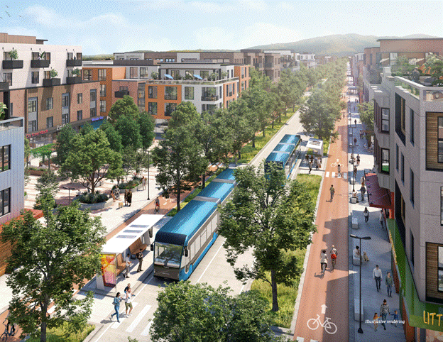
Illustrative rendering of a Suisun Expansion block, from p. 72 of the Suisun Expansion Specific Plan.
Sramek exudes confidence that the choices the team is making are the right ones. His brio rests on a straightforward historical argument, which is that humans have had cities for thousands of years but the car for only twelve decades, meaning that building streets for people, not vehicles, is the more-respectable assumption to make. Cities built on the pre-car model remain, in his word, “beloved”, and so too will new ones.
None of this guarantees the outcome. Locking in good physical form is necessary but not sufficient. Density minimums and protected lanes create only some of the preconditions for transit-oriented urbanism.
That means the rest of the Expansion’s mobility strategy must furnish the remaining ones.
Escaping the Cold-Start Problem
Most people only change their travel habits when they move to a new residence, or change jobs. A brand new community, whether a new city or a new neighbourhood, therefore faces a stark problem:
A) If there is not a robust transit option for people to use when they arrive, they will simply drive everywhere. If transit arrives later, their habits will be set, and they won’t use it
B) If there is a robust transit option for people to use when they arrive, it will be hideously expensive to build and operate, because there will be initially very few users to provide offsetting fare revenue; this typically means that the transit provider can’t sustain the service
Most new neighbourhoods, given this set of circumstances, choose a third option:
C) Run a transit option, but a minimal service: long trips to the nearest hub, or low frequencies, or both. This is cheap to offer, but is not useful, so most people opt to drive, and low ridership numbers never support the case to build new service.
This is another manifestation of the Endless Emergency.
The obvious way to solve this problem is to choose B), and bite the bullet: pre-commit to running good service in advance of construction, as long as it takes and as much as it costs, to bootstrap the new line into viability.
It’s much easier said than done. Toronto has a ‘transit first’ policy on the books that amounts to this approach, but despite decades of new development along the city’s eastern waterfront, has never run better service than a few sad buses.1 All the residents and students who live and study there have therefore made the rational choice to drive.
Another way to finesse the difficulty of B) would be to foreclose the driving option by deliberately not providing driving infrastructure, like parking facilities or multi-lane roads. This would ensure a customer base for early transit and forego the immense cost of auto-centric infrastructure.
This is also much easier said than done: almost every place in North America requires a car to get to, so denying easy auto access to a new urban area seems like a concession that new residents would never accept.
Despite the difficulties, the Expansion is taking B), and using both approaches: pre-committing to transit, and imposing friction on private car use.
This is a heroic approach, but they are being smart about it. California Forever is designing the Expansion’s first neighbourhood to be one where everything is available without transit. When everything in the area is available on foot or by bike, a bus network is initially superfluous to a safe, legible pedestrian and cycling environment. That’s what the Specific Plan’s greenway network and fine-grain block structure aim to provide.
Later, as more neighbourhoods are built, it is the transit grid that will connect them. Sramek showed me a map of the planned network: a grid structure that allows any resident to reach anywhere in the city via a two-seat ride, moving along one axis and transferring to complete the trip on the other.
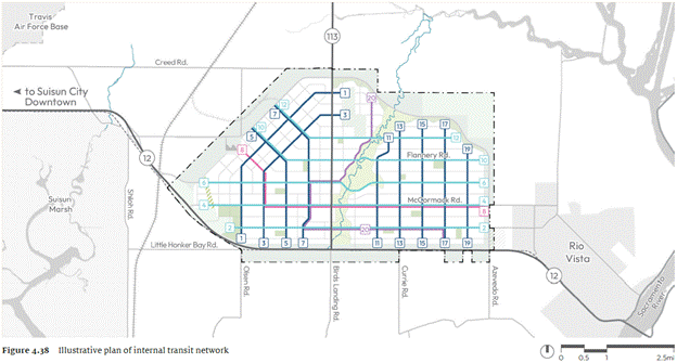
The Suisun Expansion’s planned transit network. Coloured lines indicate transit routes. Figure 4.38 (p. 115) of the Suisun Expansion Specific Plan.
At first glance, this may seem an obviously sensible approach. At second glance, though, concerns arise. The classic objection to grid networks is that most trips require the patron to board a vehicle, alight, wait, and board a different vehicle. This friction, which transport planners call the transfer penalty, is something that riders hate, so much so that on the margin it discourages transit trips in favour of direct rides, which transport planners call a one-seat ride. The obvious way to obtain one is by hiring a vehicle: yesterday a taxi, today an Uber, tomorrow a Waymo.
California Forever addresses this problem by tackling the transfer penalty directly and indirectly.
The direct approach is simply to keep frequency high. Transport planners measure frequency through headways, the amount of time that passes at a stop between the presence of two vehicles running the same route. The Specific Plan mandates 15-minute peak headways as a floor, which will mean a transfer wait averaging under eight minutes. Sramek cited Zurich and Tokyo as reference models here; both run grid-adjacent networks at high frequency, and neither has a meaningful transfer-penalty problem. A grid with frequent service works like an intersection with a well-calibrated traffic signal: the wait is predictable, so it is tolerable.
The indirect way to address the transfer penalty is by running a high-quality service. Riders consistently overestimate how long they will have to wait when they transfer, which seems to be a fixed feature of human cognition, and one that can’t be remedied. But another such feature which can be remedied is this: the worse the conditions in which passengers must wait—too cold or hot, dazzlingly bright or dark, dirty and/or vandalized—the worse their overestimations. By providing high-quality vehicles and shelters, with good wayfinding, rider discomfort will be reduced, and so will the transfer penalty.
One of the ways the vehicles will be high-quality is that they will, if possible, be automated.
Sramek believes that the Expansion’s initial transit shuttles will very likely be self-driving. (He didn’t mention it specifically, but the form factor and range of Tesla’s Robovan make it an obvious candidate.) Early embrace of shuttle automation is less about reducing the transfer penalty, though doubtless that will be welcome, and more about keeping costs low. By the time California Forever is ready to deploy them to the Suisun Expansion, automated shuttles should have a high capital cost but a low per-kilometre operating cost. In the Expansion’s early, low-density and low-ridership phases, sustainable operating costs will enable the frequent service that is prerequisite to success.
Not Car-Free, but Car-Optional
Suisun Expansion will not be a car-free city.
Sramek is explicit about this, and the Specific Plan reflects it. The goal is not a city where cars are excluded, but a city where transit and active transport options are sufficiently good that most residents choose them, most of the time. The obvious contribution here is the wall of perimeter garages. Cars are welcomed at the edges, parked in shared facilities, and residents complete their last-mile journey by transit, or perhaps by bike or foot.
This is how walkable pre-car cities used to function. The early Nero Wolfe novels, set in 1930s New York City, are perhaps the most accessible illustration of this today: on the (rare) occasions when Wolfe wants to take a car trip, his factotum Archie Goodwin must first walk a few blocks to a garage, pick up the car, and then drive it back to Wolfe’s brownstone. Goodwin, when he wants to travel through New York, simply walks. In the later novels, written after 1945, Goodwin simply parks the car right in front of the brownstone, and walks less. The difference is the friction of the intervening few blocks. A car in a garage adds just enough inconvenience to make travel alternatives attractive without removing the car’s utility altogether.
Suisun Expansion’s residents may have access to an amenity unavailable a century before: an automated car that can be remotely summoned to the residence. This feature would preserve the utility while maintaining the friction, which is the optimal arrangement. Perimeter parking is doing good work here.
Nonetheless Sramek is realistic, and expects that most residents will use their cars when taking trips outside of the Suisun Expansion, at least in the early and medium term. “The majority of people will drive,” he told me, “because they are in Northern California and that’s how people get around, even in existing cities. If people mostly walk, bike, and use transit within the Expansion, we still will have made a massive contribution to the region in terms of walkability and transit.”
I think he’s right about all of this; as much as Suisun Expansion is being designed to make car-free travel genuinely practical, it can’t change the fact that many residents will want to travel elsewhere in the region. For those trips, many (most?) people will drive. All the same, Suisun Expansion can help, and is considering how to do so. Options under discussion include running shuttles to the Suisun-Fairfield Amtrak station, San Francisco’s Transbay Terminal, nearby BART stations, and the Vallejo Ferry. Speaking only for myself, I think the private intercity bus market, which responds quickly to demonstrated demand, will be happy to help serve these destinations as well.2
Two Gaps to Fill
For all the good work that Sramek and California Forever have done, the transportation problems are not yet completely solved. I can see two gaps that need to be filled.
Firstly, goods delivery is unsolved, a fact that Sramek acknowledges. Last-mile delivery will be structurally difficult in a low-car environment. Conventional urban neighbourhoods can accommodate cube trucks and delivery vans, though in a clumsy and unsafe fashion: there are driveways, curb spaces, and sometimes wide lanes. In the Expansion’s narrow-street, high-pedestrian environment, such vehicles will have nowhere to go, meaning that deliveries don’t get made… or that the public realm will be obstructed.
There are a few paths forward. Delivery companies serving Suisun Expansion will be forced toward smaller vehicles, much as they do in old-world environments like Barcelona’s Gothic Quarter: vans rather than trucks. The Expansion can go further by requiring sufficient provision for freight in the building code, namely dedicated pick-up-and-drop-off zones for larger buildings, and/or adequate loading docks, optimized for easy entry and exit by vans. They can do the same for delivery drones on building roofs. The Specific Plan has some references to this, but more will be needed.
Failing this, they should talk early to entrepreneurs who want to help them deliver micro-hubs that would replace delivery to individual buildings within a block with delivery to a single touchpoint. Readers of Changing Lanes will remember my interview with freight expert Sandra Rothbard, who also worked with me at Sidewalk Labs, on the various ways new developments can accommodate freight delivery in an affordable and sustainable fashion; all apply very well to what California Forever is aiming to do.
The team is also thinking about commercial and industrial goods movement. A historic right-of-way running through the site—the old Sacramento Northern corridor, partially intact—offers the possibility for freight service from the Foundry and Shipyard, the new city’s industrial sectors, to the main line.
Secondly, the physical plan is ahead of the operational plan. The Specific Plan is detailed and serious on built form; it is less developed on the governance and financial architecture of transit operations. What the transit agency will look like in practice, how it will be funded at scale, and what triggers determine when routes are added and frequencies increased, are all underdeveloped.
This is not unusual for a project at this stage of development; design decisions must come first. But I note that it is matters like these that will determine whether transit-oriented design produces transit-oriented behaviour. Physical form creates the preconditions, but operational architecture is what activates them. Fortunately, the Specific Plan is doing the harder of the two jobs. The job ahead is easier. The TMA model is a promising first step, but it depends on employer and resident participation. A step in the right direction would be to require that all employers and residents join the TMA, much as college students are obliged to pay dues to the student society.
Just as the residents of Levittown today live with the consequences of choices made in 1947, by people who are long dead, California Forever’s choices this year will outlast everyone making them. A resident of Suisun in 2075 will live in a physical environment shaped by the decisions Jan Sramek and his colleagues are making today. To their credit, they understand the opportunity before them, and their plan reflects it. They are moving decisively to lock in the preconditions for transit-oriented urbanism into the Expansion’s infrastructure.
You may think that Suisun Expansion, as described here, is not a place that you would like to live; that you’d prefer an auto-centric suburb, with wide lots, wide roads, and no friction to driving. That’s a reasonable preference, and one that deserves to be satisfied. Fortunately, it’s easy to satisfy: the choices Levitt made in 1947 have dominated for decades, and remain available to every developer breaking ground today.
Suisun Expansion is one of the few American projects in generations to make it differently, and allow people with a different set of preferences an affordable opportunity to live a rich, full life without needing a car.
I hope that, in its own way, it is as influential on our future as Levittown has been on our past.
Respect to Andrew Burleson for feedback on earlier drafts.
For clarity’s sake: what is “sad” is not the fact of conventional bus service. I am a former BRT designer, after all! But I will testify in any court that running 30-minute headways, i.e., buses that only come twice an hour, is “sad”.
Over the long term, there are interesting possibilities with rail service, but those questions are the business of the region or state, beyond the scope of what California Forever can address, or should be expected to.
Who should make the most important decision in Solano County history?
So we can argue the merits of California Forever’s proposal to build a walkable city – do you believe that this utopian vision is their real plan or do you cynically believe this is a land speculation scheme to rezone ag to residential to make money?
We can talk about traffic, we can talk about who will pay for the hundreds of billions of dollars of infrastructure, how will you pay for schools, what are the societal impacts, is it worth it to destroy the most sensitive habitat in Solano County (and do the mitigation measures really mitigate?) but….
All of this bypasses the key question: who makes the decision?
Do you build an Oakland/ Minneapolis/ Tulsa/ Bakersfield sized city if a supermajority of the residents (and voters) passionate oppose it?
Under current County law the decision on whether to build an Oakland sized city within Solano County – nearly doubling the population of the County must be submitted to the voters. But multiple surveys indicate that a supermajority of the voters hate this idea – and hate it with a passion. And most people in Solano County don’t trust that a group of billionaire Silicon Valley land speculators have their best interests at heart. California Forever has figured out a way to bypass this vote.
Under current Solano County law – that has governed land use for forty years – all development occurs within current city limits. This minimizes infrastructure costs, prevents urban sprawl, and reduces the urban-rural interface. The entire land use philosophy of Solano County had been crafted to prevent a new city conjured from scratch by land speculators. The California Forever plan violates the core principles that Solano County has followed for forty years.
The Abundance Doctrine, and current policies by the California legislature, want to override local hesitancy to absorb growth-at-any cost. This is denounced as NIMBY or worse acronyms. But Solano County has absorbed more than its fair share of growth – especially in housing. The “Solano Business Park” and many other areas were rezoned residential. Many, many apartment complexes were approved in business parks zoned industrial – ours is the opposite of a NIMBY county.
Then a group of Silicon Valley land speculators secretly bought up one sixth of the County. They bought up the best protected agricultural land in California – for that reason they got it cheap. And these outsiders are trying to impose their vision on the residents of Solano County without involving the people who live here who will be affected by the massive impacts of this proposal.
California Forever has developed a terrible plan – and developed it without a shred of public input. According to their plan - the first phase occurs in the middle of the region – too far from any schools – an elementary school, middle school and high school will have to break ground immediately, along with the first houses. If you live in Fairfield, the city of Suisun has saddled you with this responsibility and its financial burden, yet you had no say.
That injustice repeats with the Fairfield-Suisun Sewer District. It’s a joint district between the two cities, the cost will be astronomical (at a time when the fees are dramatically increasing already), but under the Suisun Dodge plan the city of Suisun solely makes the decision.
A city of this size will generate traffic impacts from Sacramento to Oakland. Suisun City proposes to funnel all of the traffic from an Oakland-sized city through a slightly enlarged Highway 12 and Highway 113. For a population of this size, flow into and out of Oakland utilizes Interstate 80, Interstate 580, Interstate 880, Interstate 580, Interstate 980, State Route 24 and State Route 13. Oakland hosts AC Transit, the third largest bus operator in California. Suisun City proposes widening Highway 12. Minneapolis-sized traffic funnels through downtown Suisun and Fairfield. Again, Fairfield gets the impacts and none of the benefits.
And the plan clearly threatens Travis Air Force Base, the number one employer of Suisun County. California Forever and Suisun City claim, with a straight face, that putting an Oakland-sized city right under the most intense flight path of planes from Travis doesn’t bother the operations of the base. This flight path of Travis planes makes one half of California Forever’s planned residential areas unsuitable for schools; for this reason all of the 70 required schools must be concentrated in the southern half of the development.
Building height is likewise limited. The entire industrial park, the Solano Foundry, is located right under the most intense areas called Waypoint A and Waypoint B. The entire area is within the ALZ, the Assault Landing Zone, the Training Overlay Zone and most of it is in the Low Altitude Maneuvering Zone. If you believe that this project can be built without affecting Travis, I have two bridges across the Carquinez Strait to sell you.
This is a big decision that affects all of Solano County. California Forever has come in as colonizers and has ignored local cultures, procedures, and sensibilities. When you hear that California Forever’s proposal has been defeated, it isn’t because California can’t get things done or doesn’t want economic growth or doesn’t provide housing – it’s that a group of local activists rejected billionaire oligarchs imposing their will upon us.
As a resident of Solano County I want to emphasize just how much outsiders misunderstand our local situation. At its core it comes down to this: we don’t believe California Forever. We don’t believe anything about these plans. And we wonder “why would anyone else take these plans at face value?” "Why wouldn't people apply even a tiny amount of critical thinking to the idea that a group of investors with no urban planner or development experience are running something other than a land speculation scheme?"
A group of Silicon Valley billionaire Tech Bro nouveau-oligarchs secretly bought up the best protected farmland in California. In the beginning And then they sued the family farmers who wouldn’t sell to them for half a billion dollars – legally charging them with collusion and citing the Sherman Anti-Trust Act that Theodore Roosevelt used to break up standard oil. Everyone knows these families – they had owned the land since the Rutherford B. Hayes administration, now they don’t. A friend of mine said, “the pressure of this lawsuit is literally killing me,” and “my lawyer thinks that we will ultimately win but that legal fees will total $2.5 million.” He settled. They all did.
During the drafting of the Solano County General plan, through thousands of hours of meetings and compromise, through hundreds of public meetings, this area had been set aside as agriculture, open space, and wildlife habitat. This preservation was especially important since it lies directly under the most intense flight path of Travis Air Force Base, a base critical for national security and the number one employer in Solano County. So through the initiative process Solano County citizens strengthened this land use designation in a way that requires a County-wide vote to rezone it from agriculture. Therefore it was a fraction of the cost that ag land in the path of development would have commanded. So ironically it was this powerful protection that made it vulnerable to these land speculators.
We have seen the plans for a:
The new city will be a livable and self-contained, 15 minute, walkable, mixed use, one hour metropolis of sustainable development with a multi-use diverse functional land use mix that produces an interconnected diverse multigenerational community that integrates active mobility and celebrates art and heritage through adaptive reuse while protecting history cultural landscapes and open spaces. The street grid system is designed to generate a regular cadence emphasizing walking and biking.
OK, I made up that planner-speak word salad.
But we wonder why anyone would believe that a group of Silicon Valley investors headed by a former Goldman Sachs trader is really interested in reinventing urban planning rather than merely in the age-old strategy of buying farmland and making money the night that it gets rezoned. We wonder why anyone thinks that this would be something other than a San Fernando Valley-style bedroom community for Sacramento and San Francisco with a sea of tract houses and strip malls. Trust? With their history in our County, trust is very hard to come by.
There has been no democratic input into these plans – none, nada, zip, zero. Usually a General Plan process involves citizen input, committees, meetings – there has been none of that. These are their plans – with no input from the community. Their “community meetings” communicated “this is what we are going to do” and frankly became sessions where the frustrations of the excluded locals boiled over to have each meeting become a shouting match.
I imagine that many of the audience here are planners. They are doing this without going through the General Plan process - an Oakland City size with a General Plan Amendment that you might use for a minor subdivision. Again, there has been no public input. This is complete privatization of planning. The proponents fully recognize that they must carry out their plans over the objections of a super-majority of the residents - there is massive opposition.
The scale of this proposal is huge. Broligarch City will be the size of Oakland or Bakersfield or Tulsa or Minneapolis and bigger than New Orleans, Honolulu, Cleveland, or Cincinnati – all carried out outside of normal planning practices with no citizen input. Under County jurisdiction its approval requires a majority vote of County voters – when their polling showed a super-majority of voters opposed, California Forever withdrew their initiative. Currently they are attempting to weasel their way around this requirement by exploiting the financial difficulty of Suisun City, Solano County’s second smallest city, to have them annex the land – seven miles away across a 7 mile stretch that Travis Air Force Base makes undevelopable. It’s a leap-frog development using a cherry stem annexation.
A parallel article written by H. Pike Oliver criticizes this article. https://www.urbanexus.com/pikeurbanexuscom/2026/5/2/andrew-miller-on-california-forevers-mobility-vision-what-must-be-locked-inand-what-he-leaves-out? That article correctly concludes: “Even a highly walkable, transit‑ready city of 400,000 would generate a massive increase in regional automobile traffic—an issue Miller does not address.” But Oliver's article still minimizes the the certain – not potential – impacts.
The proposed city basically operates as one big cul-de-sac. There is a choke point to the East – the narrow bridge between Rio Vista and Sacramento County. Highway 12 is currently a mess and seems to be near capacity. Midday mid-week traffic does not flow very well. Highway 113 is narrow, tiny. The proposal envisioned in the Specific Plan is merely to double these. The Specific Plan proposes, with a straight face, to build an Oakland sized city serviced by minor expansions of Highway 113 and Highway 12. You would think that assessing the impacts of an Oakland-sized city would be… Oakland.
For this population size, Oakland is serviced by a network of freeways, BART, and the third largest bus system in California. Flow in and out of Oakland utilizes Interstate 80, Interstate 580, Interstate 880, Interstate 580, Interstate 980, State Route 24, and State Route 13. It takes an entire network of massive Los Angeles-style freeways to service a city of this size and to handle the flow of traffic through the city. In addition, Oakland makes up is a major part of the Bay Area Rapid Transit system. Oakland hosts AC Transit, the third largest bus operator in California.
Broligarch City will have Highway 12.
I invite everyone to do this thought experiment. Imagine the operation of the City of Oakland if the ingress and egress was a slightly expanded Highway 113 and a slightly expanded Highway 12. Do the thought experiment of placing Minneapolis, Bakersfield, Tulsa, Tampa, Arlington, Aurora CO, or the smaller cities of Cleveland, New Orleans, Honolulu, Anaheim, Lincoln, Riverside, Stockton, Orlando, Newark NJ, Cincinnati, Pittsburg PA, or Durham NC into this blind traffic cul de sac with a Highway 12 that isn’t elevated and runs through downtown Suisun City and Fairfield with 6 traffic lights on its way to Interstate 80.
It would be nice to have a walkable city. If you believe that the California Forever proposal is it, I have a bridge across the Carquinez Strait that I would like to sell you.